Quick Contact
For all enquiries please contact one of our friendly staff on +64 7 282 1593 or Contact Us

“The Pinnacles (759 metres) are a serrated outcrop of rhyolite that formed around 8 million years ago. Like a toothed saw they cut the skyline. From the summit there are views along the entire length of the Coromandel Peninsula, from Mount Moehau to Mount Te Aroha.”
The Pinnacles track starts roughly 22km inland from Thames, and follows the original packhorse route that was used to carry supplies to the kauri loggers during the great deforestation of the 1880s – 1920s.
It is a well known and popular intermediate-grade walk that is suitable for most people with moderate to high levels of fitness. Whilst the track is mostly uphill and quite steep in some parts, the walk is child friendly and short enough to do in a (long) day trip.
In this guide, we take a close look at everything you need to know about The Pinnacles track and what to expect.
Here’s a table of contents:
Here are the three most popular questions that people ask when thinking about climbing The Pinnacles:

The walk is estimated to take 3 hours and 40 minutes from the road end to the summit. However, this estimate is based on averages. As it is an extremely popular hike, the time estimates signposted around the track are quite conservative.
If you have a high level of fitness, expect to climb it in 2.5-3 hours one way. If you are planning to climb The Pinnacles and return on the same day, allow 6-8 hours for the round trip.
The climb is quite steep in parts (with large stone steps and ladders), and it is common for people to take regular breaks on the way up. The return trip back down is quicker than the ascent.
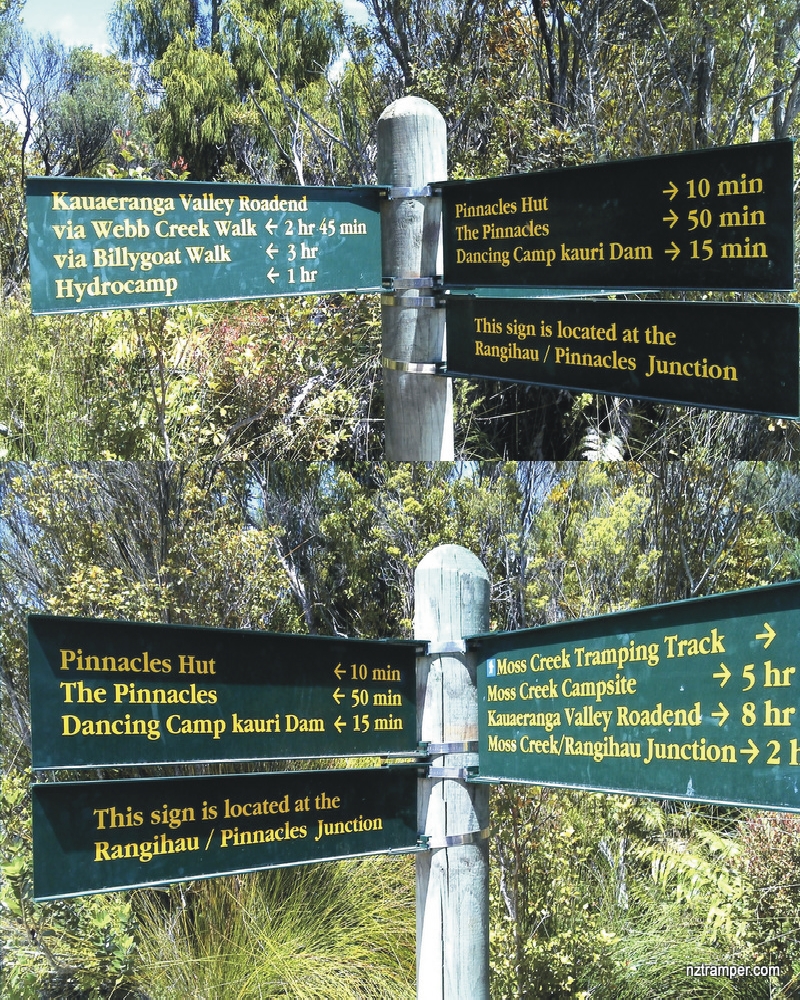
According to the Department of Conservation, the distance to Pinnacles Hut is 6km one way if you take the Webb Creek track, and a further 1km to the summit. If you return via the Billygoat Track, you will travel a slightly longer distance.
With this in mind, you can expect to walk for roughly 14-15km round-trip. Click here for a map of the trails around the Kauaeranga Valley.
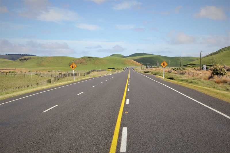
The Pinnacles walk starts at the Kauaeranga Valley Road End. To get here, follow the Kauaeranga Valley Road past the Department of Conservation Visitor Centre (13km from Thames), and past the campsites that line the roadside.
You’ll know when you have reached the beginning of the track, as there is a sizeable carpark and signs indicating the beginning of the track. This drive takes roughly 40 minutes from Thames.

Here are a handful of reviews from people that have walked the track and shared their experiences:
“We booked a DOC site at the base and arrived late in the dark. Driving up the road we saw glow worms in the banks and heard a kiwi. At 8am we started walking, it only took about 2 1/2 hours to the top and the views were stunning. There are a few steep steps and I was grateful for my walking poles both up and down. I was impressed with the number of families walking up with small children and also glad not to see one piece of litter on the track”
“Climb for two or three hours up the track (depending on your fitness) and reach the Pinnacles hut. Then another 30-50 minutes to the peak. The view is breathtaking and well rewards the effort. Go for the day only or stay the night. The hut is superb and well equipped. The benefit of staying is catching the sunset or sunrise. Yes it is an effort to make and a degree of fitness is required but the reward is worth it”
“The walk up is all up hill so you need to have an okay level of fitness especially as the steps are relentless. We came back down the Billy Goat track which was a little longer and if you have knee problems wear good support for them. While the hut was full (80 people) it didn’t seem that way as people just got on with it. The sleeping part is also away from the eating/socialising area. There were lots of pots and dishes etc so you could get away with not bringing any if you want to keep your pack light. We got up in the morning to walk up the Pinnacles and watch the sunrise. It is easier getting down than up so don’t be put off.”
The Pinnacles walk is located in the Kauaeranga Valley, which is about a 40 minute drive from Thames. We recommend stocking up on supplies in Thames before embarking on the journey. Here are some instructions on how to get there if you are driving:
The quickest way to get to Thames from Cambridge is via the following route:
If you drive nonstop, this takes about 1 hour and 20 minutes – passing through Morrinsville along the way.
As you get closer to Thames, you will pass through a village of commercial and industrial buildings called Kopu. If you’re hungry and would like to fuel up on delicious pies and baked foods, check out the bakery on Kopu Road near the big roundabout – it’s a local favourite!
The drive from New Zealand’s largest city, Auckland, takes a bit longer and passes through busier roads that can become congested during peak times such as public holidays.
The drive takes around 2 hours and 20 minutes from the city centre. However, this is entirely dependent on traffic. During peak hours and public holidays, it is common to experience traffic jams between Manukau and Pokeno so make sure to allow for extra time if you anticipate heavy traffic.
Once you take the State Highway 2 offramp towards the Coromandel, the road takes you across the Hauraki Plains and crosses the Firth of Thames. About half of this section is a 90km road.
Once you arrive in Thames, you may want to stock up on supplies and prepare for the upcoming adventure. With amenities such as a supermarket (Pak N Save), petrol stations and outdoor equipment stores (such as Hunting & Fishing), it is easy to gather all the last minute necessities in one place.
To get here from the main road in Thames, turn inland onto Banks Street when you reach the BP petrol station and follow this road onto Parawai Road. From here, follow the road until you arrive at the Kauaeranga Road End Carpark.
The Department of Conservation Visitor Centre is located about 8km before the beginning of the track on the left hand side of the road.
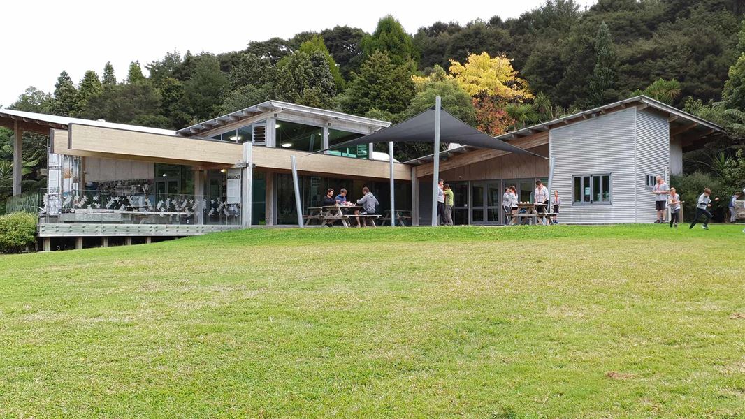
Here, you will find a large information building with DoC staff on hand to help. They are able to supply hut tickets (although it’s best to book online to avoid missing out and paying extra fees), provide weather forecasts and information about track conditions, and answer any questions that you may have. There are also educational displays scattered around this large building that provide insight into the terrain, introduced pests and more.
During the final leg of the journey to the roadend, you may notice a handful of campsites dotted along the roadside. If you’re planning to climb The Pinnacles as a daytrip, these are a great place to stay and unwind afterwards.
Unfortunately, there is little in the way of public transport around the Coromandel for those that don’t have access to a vehicle.
If you’re travelling from Auckland, it is possible to take a ferry to Coromandel township with Fullers (timetable and pricing here), and connect this with a return shuttle service to the track entrance (more information about the shuttles here).
If you decide to take this option, you will need a minimum of four people for the shuttle to operate.

There are two tracks that can be taken up to The Pinnacles Hut: Webb Creek Track and the Billygoat Track. Most people climb up the Webb Creek Track and some decide to return via the Billygoat Track (which takes longer that following the same path back down).
This route was named after Sam Webb – the man who was given the original contract to mill the surrounding Kauri forests in the 1880s. This walk can be broken down into a couple of distinct ‘legs’:

“From the car park to the first junction takes around 20 – 30 min. From here the track undulates a little, then rises steeply to the first swing-bridge. If the water level is low, you can just cross over the rocks…use common sense naturally. From the first swing-bridge, the stone stairs come into play – it will take 1–1½ hrs to leave them and get to the logging camp. It’s not all stairs, but they are what you’ll remember most.”
This section of the track is well-maintained and relatively steep in some places. The steps are taller than normal stairs, as they were made for bullocks carrying supplies to loggers in the early 1900s.
“The path then flattens out on the summit plateau of the ranges. It remains wide, well-maintained and signposted on the way to Pinnacles Hut.”
As you walk along this section of the journey, you will notice a set of giant power lines that carry electricity to the east coast of the Coromandel Peninsula (from Thames to Tairua).
These were constructed during the 1940s. During this time, the Hydrocamp was used as a base for workers to stay. In the deforestation era of the 1880s-1920s, loggers stayed here during their stints in the forest.
“It’s a good place to stop and rest, have some food and appreciate how high up you’ve come. There’s a long-drop hidden in the trees at the Northern end, if needed.”
From here onwards, the terrain features a different mixture of plants, with more mountainous shrubs and mānuka/kānuka lining parts of the trail. During periods of high rainfall, it is common for this area to become muddy and slippery.
After departing the Hydrocamp, you can expect to walk for another 30-60 minutes before reaching The Pinnacles Hut.
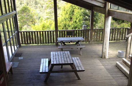
“This has to be the most AWESOME hut I have ever seen. The old hut (which was damp and yuk), is now the warden’s house. The new hut, which cost several hundred thousand dollars, is immaculate (for huts anyway)… It’s all decked, so once you’re there, no muddy boots needed to get to kitchen, toilet wherever.”
The Pinnacles Hut is one of New Zealand’s most popular DoC huts, with a large amount of beds and a spacious communal area. Here are some of the key features that you will find around the hut:
“If you are lucky, the warden (on weekends usually) can get the generator out at night and give a 1 hour slide presentation in the kitchen, showing photos of the history of Thames and the Kauaeranga Valley.”
If you’re planning to stay at the hut, it’s important to book ahead of time, as this hut is very popular – especially during the summer! Click here to check the availability and secure your spot. Adults fees are $15 per person, children (5-17 years) cost $8 and infants (0-4 years) are allowed to stay for free.

“This was the second largest dam in the Kauaeranga and was built by Jim Angel in 1924. The gate planks were attached by cables and could be reset after each drive.”
There is a signposted walk to visit this dam, which takes 5 minutes each way and sheds a bit more light on the history of the area. Here, you will also find a DoC campsite that often takes the overflow when the hut is fully booked. Fees are $5 per night.
For more information about the dams around this area, and how they were used in the logging industry, check out this resource.

At 759m altitude, The Pinnacles summit offers panoramic 360 degree views that stretch from Tairua to the Kaimai Ranges and cover much of the Coromandel Peninsula.
This last section of the hike is steep, rugged, can be boggy in parts and features ladders at the very top to reach the summit. Whilst it’s not for the faint hearted, those who reach the final rocky outcrop will be rewarded with unrivaled scenery (on a good day).
It’s important to take care on the last section of the climb to avoid falling and being injured. There is a safety barrier at the summit, and visitors are advised not to go beyond this area.

If you’re planning to stay in The Pinnacles Hut, it is best to time your ascent around sunrise or sunset (or both). Not only is the summit a great place to welcome or farewell the daylight, but these periods also provide the best conditions for scenic photography.
In terms of seasons, the best weather conditions normally occur around summer and autumn (December – late April). However, this time of year also coincides with the peak tourism season, so you can expect to find lots of other people on the track.
During the winter, there are generally less people here, but you’re also more likely to experience bad weather that limits your views and makes the track muddier.
Either way, keep an eye on the weather forecast and look for fine periods of sunshine. If you are able to visit during the week, the hut and trails are more likely to be quiet.
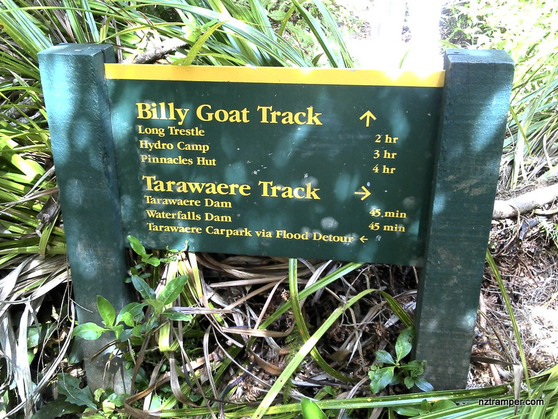
“The Billy Goat Trail starts at the logging camp – instead of going right and heading for the stairs, you go sharp left after the stream (north-west), walk past the power company hut and follow the trail.”
The terrain varies as you proceed along the Billygoat Track, with undulating terrain that winds around the side of hills and features some steep climbs. Before this area became a popular recreational spot, there was an old wooden bridged railway running down to the bottom of the valley.
“At about the ¾ mark (1½ hrs), there is a small marked diversion (trail) which can show you the remains of the main rail logging bridge. Alas, the bridge was blown up by army engineers thirty years ago when it was deemed unsafe, so there’s not much to see, but since your there you may as well look.”
From here, the trail mellows out as you traverse a few more valleys. The last half an hour is steep and downwards, taking you to the bottom of the valley. Once you reach the bottom, the track takes you across the river and a few hundred metres back to the road end.
Here’s a list of items that you should consider taking with you on any day hike (provided by Department of Conservation):
Essentials:
Clothing:
Other things to consider:
If you’re planning to stay overnight, you’ll also want to bring a sleeping bag, another set of clothes, food for dinner and breakfast, a toothbrush, toothpaste and an inflatable pillow.
Unless you decide to camp at the bottom of the track or book a night in The Pinnacles Hut, you’ll probably be wondering what’s available in terms of accommodation. Depending on the time of year that you visit, the Coromandel Peninsula may be extremely busy (summer) or very quiet (winter).
This is partially due to tourism during the peak season. However, it’s also a holiday hotspot for locals, with many of the houses around Thames and Coromandel being used as baches (holiday homes).
Here is a list of websites where you’ll find a range of accommodation options that cater for all budgets and tastes:

There are a few towns around the Coromandel Peninsula that are worth considering for accommodation – depending on how much time you have at your disposal:

“Hidden Lake is a luxe new Hotel with a broad palette of natural, sustainable and design aesthetics. Comfort is defined in its leisurely manner. Rooms and apartments reflect the woodland setting with floor to ceiling windows and splashes of colour.”
We are nestled on the shores of Lake Te Koutu in Cambridge. Not only does our hotel offer a private retreat away from the rugged beauty of the Coromandel, but it’s also 20 minutes drive from Hamilton Airport.
Click here to get the best deal by booking direct.

The story of how Thames and the Kauaeranga Valley have changed over the last 160 years is one of industrial hubris and fervent greed. Prior to European settlement in the area, the untouched forests supported a diverse array of life. Of all the trees in this area, kauri was the most significant.
“Dominating the canopy with a monumental presence, the gracefully spreading crowns were supported by straight untapering boles of monolithic proportions. With a girth commonly exceeding 10 metres (although rare today) and a height to the crown approaching 50 metres, the kauri was once king of the Kauaeranga Valley forest.”
When gold-bearing quartz was discovered near Thames in 1867, the gold mining boom of the 19th century extended to the Coromandel Peninsula and within a year the population of Thames increased to 18,000 people.
To support the booming mining industry and create infrastructure throughout the region, kauri was logged and used as a key resource for early settlers.
In the beginning, easily accessible trees were felled. Coastal forests were decimated first – followed by more rugged terrain throughout the Kauaeranga Valley later on.
Between 1871 and 1928, the entire kauri forest of Kauaeranga Valley was felled. For a more detailed account of events, check out this article (in particular, the section named ‘Feature’).
We hope that you have found this detailed guide of The Pinnacles useful. For more ultimate guides to local activities around Waikato and the Coromandel, check out our blog.